Got a question? Just ask!
Planning your Remutaka Cycle Trail Adventure can be a bit overwhelming. This guide helps answer your questions and makes planning a trip as easy as possible. If you still can’t find the answer to your queries though, just get in touch!
General
Is there anywhere I can get a decent map of The Remutaka Cycle Trail?
What's the difference between The Remutaka Cycle Trail and The Remutaka Incline Trail?
What's the best time of year to cycle The Remutaka Cycle Trail?
Bikes & Equipment
What kind of bike do I need to ride The Remutaka Cycle Trail?
What gear or equipment should I take with me on the coastal section of The Remutaka Cycle Trail?
Accommodation Options
The Wild Coast (coastal section between Ocean Beach and Orongorongo)
General
What grade is The Remutaka Cycle Trail?
From Days Bay to Maymorn is Grade 2/easy. Maymorn to Cross Creek is Grade 2–3/easy–intermediate. Cross Creek to Ocean Beach is Grade 3/intermediate. Ocean Beach to Orongorongo is Grade 3–4/ intermediate–advanced. Orongorongo to Days Bay is Grade 3/intermediate.
How long is the trail?
If riding the official trail, 115km. But don’t worry, you don’t have to do it all in 1 day! Choose from our 2, 3, 4 or 5 day options:
2 days - if you're really fit and keen, you might wish to condense it into a 2 day trip, but we wouldn't recommend it for most riders. If you're unsure, we'd recommend either stretching it out to a 3-day trip, or considering using an eBike to take the edge off. We can also start you off a bit further up the Hutt River Trail if you've only got two days but want to see the best bits of the trail.
3 days - this suits the vast majority of our clients. If you're of average fitness (go for the odd bike ride at weekends but not entering Le Tour de France anytime soon, comfortable with activities like tramping the great walks etc), we recommend you take at least 3 days to ride. You'll cycle no more than 55km on any day doing it this way, and for most riders it seems to be a good balance between getting a decent ride in each day while still having energy to enjoy the evening.
4 days and over - some of our clients like to take a bit more time to check out the views and info along the way. It's also possible to add a night or two in Martinborough to your itinerary, sampling the region's wine and food scene. If you're not in a rush, then why not?
Where does The Remutaka Cycle Trail actually start?
The official start point is in Petone, next to the wharf. You can get to Petone by ferry, train, or bus from Wellington, or if you're booking in for one of our packages, we'll pick you up from your doorstep in our shuttle and take you out there. We’d highly recommend riding it from Days Bay: you can either take the East by West ferry to days Bay from Wellington CBD, or we can shuttle you out to Days Bay if booking in for one of our package deals. There is also plenty of free parking at Days Bay, and easy access via bus.
Is there anywhere I can get a decent map of The Remutaka Cycle Trail?
Yes! Check out our interactive Google Maps here. If you’d like a paper copy, just send us an email at remutaka@wildfinder.co.nz, and we'll send you a printable pdf of our maps including detailed trail notes.
What's the difference between The Remutaka Cycle Trail and The Remutaka Incline Trail?
The Remutaka Cycle Trail, is the whole 115km long trail network that runs from Petone to Orongorongo, of which the Remutaka Incline Trail (sometimes referred to as The Remutaka Rail Trail) forms a 25km section, starting at Maymorn and finishing at Cross Creek.
What's the best time of year to cycle The Remutaka Cycle Trail?
It can be completed all year round - the Remutaka Summit will sometimes get a very light dusting of snow, but there's no reason the trail can't be completed mid-Winter. There's pros and cons for every season - Summer gives you the best chance of hot weather (but sometimes uncomfortably so and it can get quite windy), Autumn and Spring are quite variable, while Winter is obviously colder but can be calmer too in terms of the wind (and you can get some amazing views out over the Cook Strait to the Kaikoura Ranges on a clear Winter's day).
Are there any toilets?
Yes - there are public toilets dotted all the way around the trail, though very few between Cross Creek and The Wild Coast. Check out our trail maps for exact locations.
Where can I fill up with water?
There are a few spots along the Hutt River Trail, but we would always recommend filling up at least two bottles before you leave your accommodation each day. Please note there are no water stops along The Wild Coast / Orongorongo sections - see our trail maps for exact locations.
What’s the mobile phone coverage like?
Variable - most providers get full coverage on the Hutt River Trail, and around 75% coverage on The Remutaka Incline Trail, but from that point onwards all providers have quite a few blind spots, especially around the coast (Spark is by far the best around that area). We therefore recommend that you take a secondary form of communication with you - a Spot Tracker or EPIRB for example.
Bikes & Equipment
What kind of bike do I need to ride The Remutaka Cycle Trail?
The trail is one of the most varied cycle trails in the country in terms of terrain - everything from concrete paths to occasional soft sand and shingle. You can make it around the trail on just about any good quality and well-maintained bike, but for best performance and comfort across everything the trail has to offer, we recommend using a mountain or hybrid style bike with front suspension and at least 1.75" wide tyres. We find our comfort mountain bikes (take a good quality mountain bike, then make it comfortable with gel seats and adjustable geometry) the perfect fit for most riders.
What gear or equipment should I take with me on the coastal section of The Remutaka Cycle Trail?
You're very unlikely to have any issues out on the coastal trails, but access is difficult (or impossible) at times for vehicles, and cellphone reception is limited, so it pays to be prepared! With this in mind, make sure you have a first aid kit and emergency blanket, some warm clothes for when you stop (or in case someone gets injured and you have to wait for assistance), a second form of emergency communication (we use Spot trackers for our clients, but an EPIRB or similar would also be handy), and enough food and water for the group.
What's the deal with food on The Remutaka Cycle Trail?
This one's important - there's literally zero options to buy food on the trail after you leave Upper Hutt, so make sure you've got it covered! There's a few different options:
Take all of your food with you in pannier bags, and self-cater (heaviest option but usually the cheapest!)
If we're doing bag transfers for you, you can also include a chilly bin or similar full of food (we're happy to do this, and to put whatever you like into the fridge / freezer when we drop your bags off) for no extra charge.
Get us to organise food for you! We work with the accommodation providers and/or local cafes, to provide great food for your entire journey. Some heating or assembling may be required. See our more inclusive tour options for details.
Should I use an eBike to ride The Remutaka Cycle Trail?
Sure! If you're feeling a bit uncertain as to whether or not you can comfortably ride the same distance as others in your group, or you just want a more relaxed experience, eBikes are a great way to go. Just make sure that you're able to access a power point each night to recharge your batteries (this is easy at all the accommodation providers, but not so much at camp sites!). We've got a bunch of great eBikes in the hire fleet, and would be happy to help.
Accommodation Options
Do you have any Remutaka Cycle Trail accommodation providers you recommend?
We sure do! Check out our accommodation page for more details, along with a map of where our favourite providers can be found.
Can you camp on The Remutaka Cycle Trail?
Yes. There's a Department of Conservation campground about 2km off the trail up at Kaitoke (just before you go over the Remutaka Incline), and another (but much more basic) campground at Corner Creek just past Ocean Beach.
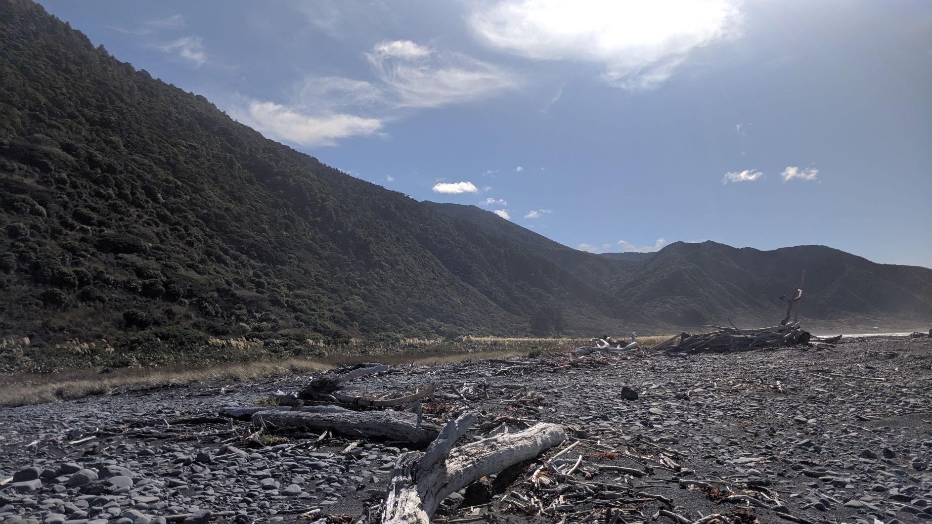
The Wild Coast (coastal section between Ocean Beach and Orongorongo)
Just how rough or tough is the coastal section of The Remutaka Cycle Trail?
It's hard to say. On it's best days (with little or no sand on the track, and after maintenance crews have gone through), the trail will be quite smooth and clean and you can breeze through in under an hour. On it's roughest days (after storms or earthquakes, or just before a maintenance crew), you can experience deep sand drifts, and shingle fans where the track gets quite rocky and bumpy, and it can take some people 5-6 hours to get through in those conditions. We find the best way to think about it, is as an 18km combination trail of mostly cycling with up to 3km of walking. Don't be put off by that though - it's a stunning trail, and as long as you go into it with the right mindset is well worth the effort!